FORCLIME
Forests and Climate Change ProgrammeTechnical Cooperation (TC Module)

Select your language
The Forest Investment Programme (FIP) Pilot Countries Meeting, hosted by the Ministry of Indonesia, was held in Yogyakarta on 24 – 26 September 2013. As a side event of the meeting, the Ministry of Forestry also organised an exhibition which consisted of several thematic booths, namely: forest inventory and monitoring system, REDD, Community-based Forest Management, and Forest Management Unit (FMU). During the exhibition, FORCLIME supported the Directorate of Area Management and Preparation of Forest Area Utilisation of the Directorate General of Forestry Planning from the Ministry of Forestry (WP3H) in displaying the current status of FMU development through a draft version of a multimedia map of FMUs in Indonesia. Currently the WP3H, supported by FORCLIME, is developing this multimedia map to disseminate information on the FMU development in Indonesia.
For more information on FORCLIME’s activities with regard to the FMU development, please contact:
Tunggul Butarbutar, Strategic Area Manager for FMU development
Gatot Moeryanto, Senior Adviser for Forestry Policy
Following up to the training on Sustainable Livelihoods Assessment (SLA) that was conducted in Malinau District in June 2013, a feasibility study on people's livelihoods for short-term investments was carried out. The study was collaboratively conducted by FORCLIME and the District Forestry Service of Malinau, with the Head of Conservation Department as the programme coordinator. The study was conducted in 15 villages in Hulu Bahau and Pujungan sub-districts in Malinau District for two weeks from August 26 to 10 September. The study team was divided into five groups, of which each group worked in 3 villages.
In addition to providing an overview of the condition in every village, the activity also aimed to facilitate the community to develop ideas related to improving their income. For example villagers at Long Lame village now plan to develop sustainable agriculture systems by planting vegetables and nuts as primary commodities. Moreover, Pujungan villagers want to develop fisheries and rubber plantations. The activity also explored public perceptions on forest utilization, particularly to identify important area for socio-economic compliance (High Conservation Value - HCV 5) and areas important for the cultural identity of traditional communities (HCV 6).
For further information please contact:
Indah Astuti (Community Participation Expert of DPMU Malinau)
Toni Salsius (Forestry Expert of DPMU Malinau)

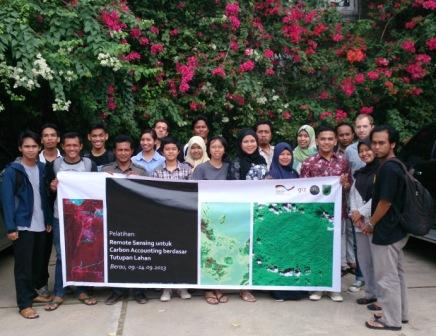
As part of its efforts to support the capacities of Forest Management Unit (FMU) staff, GIZ FORCLIME supported the Model Production FMU of West Berau (KPHP Model Berau Barat) in organizing a training on remote sensing for carbon accounting based on land cover types. The training, which belongs to a series of capacity building activities for the technical staff of the KPHP’s Geographic Information Systems (GIS) Unit, was conducted from 9th to 13th of September 2013 in Berau district, East Kalimantan. 20 participants from the Model KPHP Berau Barat, from local NGOs, the district government, FORCLIME’s National Project Management Unit (NPMU), and Kayan Mentarang National Park joined the training.
Materials provided cover the following topics: introduction to remote sensing and the devices used for this purpose, data preparation processes, and methods for land cover classification. In addition to technical materials, participants also learned about climate change, REDD+, carbon accounting, reference emission levels, as well as measuring, reporting and verification (MRV). Giving this additional information aimed at increasing participants’ understanding about the carbon issue, so that they can further apply their technical knowledge of remote sensing and GIS in the context of land use planning through considering the carbon stock of different land cover types.
The training was opened and closed by the Head of the Model KPHP Berau Barat, Hamzah, MSi. In his speech, he expressed the hope that participants will use the knowledge gained from the training for carrying out their duties. Additionally, participants are also expected to transfer their newly obtained knowledge to other colleagues who did not participate in the training.
For further information, please contact:
Benjamin Korff, Development Adviser, Geographic Information Systems
Budi Susanto, Adviser, Geographic Information Systems
 |
Supported By: |
  |