FORCLIME
Forests and Climate Change ProgrammeTechnical Cooperation (TC Module)

Select your language
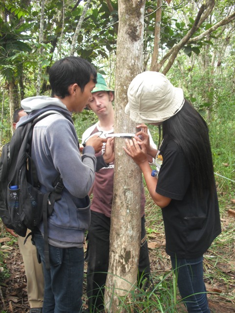
The Ministry of Forestry through its Minister’s regulation No. 47/2011 has assigned responsibility and authority to Kapuas Hulu District to undertake activities related to REDD Demonstration Activities. Designated activities include: (1) Measuring carbon stocks in forest areas, (2) Preparing the implementation of monitoring of the forest carbon storage, and (3) Preparing the implementation of carbon emission reduction from forest degradation and deforestation.
With the purpose of supporting the measuring and monitoring of forest carbon stocks, the District Service of Plantation and Forestry of Kapuas Hulu and GIZ FORCLIME collaboratively held a training course on Measuring and Estimating Forest Carbon Stocks in Putusibau from 17 to 20 January 2012. The objective of the training was to build capacities of people involved in REDD Demonstration Activities to measure forest carbon stocks using methodology that is scientifically sound. Participants were about 22 people from various government agencies, private forestry sector and non-governmental organizations in Kapuas Hulu. Instructors and facilitators of the training came from GIZ FORCLIME, from the Dipterocarps Research Center of Samarinda and from the Production Forest Utilization Monitoring Center (BP2HP) of West Kalimantan.
On the first day, participants gained basic knowledge related to global warming issues and the importance of reducing deforestation and degradation in tropical forests as climate change mitigation efforts. Additionally, participants were introduced to concepts of Monitoring, Reporting and Verification (MRV), forest inventory, and measuring and estimating carbon stocks, including developing local allometric equations. The second day was a field exercise to learn the techniques and strategies for data collection through forest and carbon inventory as well as the development of allometric equations. On the third day, participants exercised data processing of field inventory data. On the last day, participants were taught how to use the processed data for calculating baseline emissions in the region or area.
During the closing ceremony, the Head of District Service of Plantation and Forestry of Kapuas Hulu confirmed that it is important for stakeholders in the district to be able to conduct MRV accurately and credibly. Therefore, he suggested to the participants to practice, learn more and disseminate the knowledge that was explained and practised during the training. Additionally, he also mentioned the need of continued support from GIZ FORCLIME related to capacity development.
For further information please contact:
Solichin Manuri
Forest Carbon Senior Advisor
solichin.manuri@gmail.com
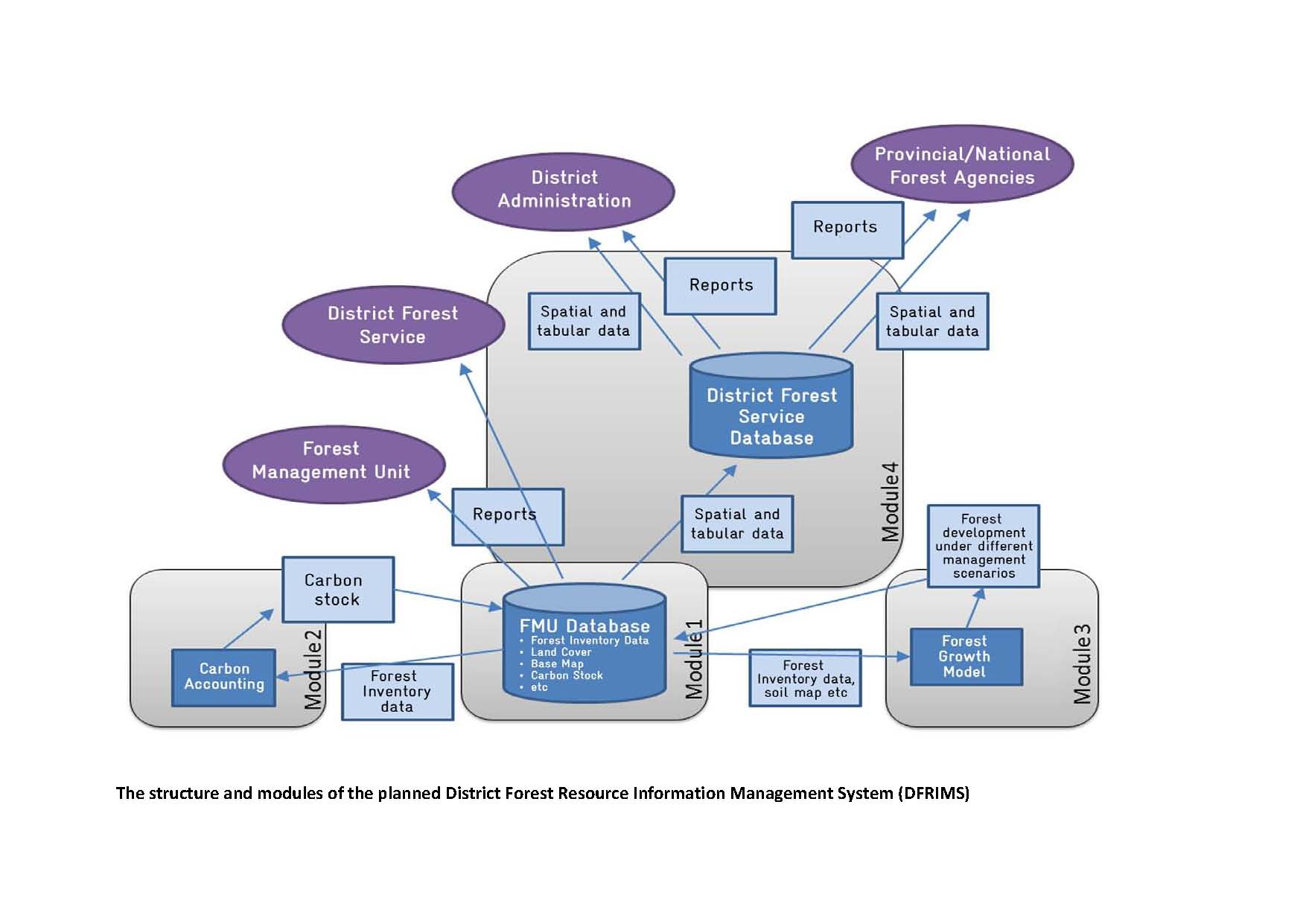
Modern forest management systems provide advanced controlling, planning, monitoring and analysis tools and procedures. Rational decision making for Sustainable Forest Management (SFM) and spatial planning needs reliable and trustworthy up-to-date information based on technical, ecological, economic and social data. An information system is one tool that can be instrumental for informed decision making in forestry. The scope of DFRIMS will be to collect, store, process and analyse data of planned Forest Management Units (FMU) and of district’s forest areas. The challenge is not only to provide continuously updated data on all forest functions but also to customize the system according to regional and local conditions. Forecasting tools regarding the steady growth process of forests hold the possibility to calculate alternative scenarios of sustainable management including various market strategies and management objectives for all forest functions. These tools will also provide data to support REDD+ activities that help to mitigate climate change and to adapt forest resources to climate change through silvicultural treatments and reforestation if necessary. The information system will also provide accumulated data for a Monitoring, Reporting and Verification (MRV) system and political decision-making at the provincial and national level by supporting a defined reporting system. Linking the DFRIMS concept to the institutional and administrative structures of FMUs will ensure that the information provided by the District Forest Resources Information System is used where it is needed.
For more information, please contact:
Dr. Markus Müller
Senior Advisor on Geographic Information Systems and REDD+
Email: markus.mueller@giz.de
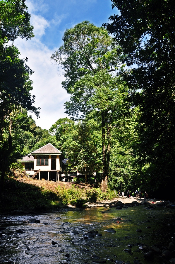
"We have been taught from generation to generation through our traditions to maintain and preserve our forests. But now, why it is so difficult and takes a long process to get a legitimate right to manage our forests? Please help us ". As expressed by Saleh Wang, the Head of Setulang village.
The village government of Setulang assisted by the Forest Service of Malinau District and GIZ-FORCLIME has proposed the protection forest area (the local language: Tane 'Olen) as their Village Forest. Village forest is a state forest that is managed by the Village people for the wellbeing of the village, considering all forest functions. A proposal for village forest development has been prepared and submitted to the Regent of Malinau. In December 2011, the Regent has issued a recommendation letter for the Setulang proposal and forwarded to the Minister of Forestry.
It is recognized by the villagers that in order to get the management rights of a village forest up to the implementation stage is a long process. Nevertheless, the recommendation letter from the Malinau Regent is one of the important steps and warmly welcomed by the government of the Setulang village. Going through the process, stage by stage, the dream of the Setulang people is to obtain certainty and access rights to manage their forest by themselves will be accomplished. It is expected that in early 2012 the Ministry of Forestry will conduct a field visit to verify the proposal and issue a letter of Working Area Determination for the Setulang Village Forest. Drs. Ihin Surang, Head of the Conservation Unit of the Forest Service of Malinau, hopes that Setulang’s efforts in obtaining the rights to management their forest as well as their efforts in conserving the forests will be serve as an example for other villages in Malinau.  Setulang village in a glance
Setulang village is located in the district of Malinau, East Kalimantan. It has a total area of 11,800 Ha its altitude ranging from 70 m to 500 m above sea level. The village lays on the banks of the River Malinau surrounded by hills and separated by a district road connecting the nearby villages. The village can be reached from the district capital in 1 to 1.5 hours by boat or by car on a paved and gravel road.
The village has 931 inhabitants living in 236 household. The majority of the dwellers are Dayak Kenyah Oma Lung being Christians and still adheres to traditional customs. Main livelihood of the locals is farming. The village is led by the head of the village government that governs the village. Additionally; there is also a customary authority which administers traditional norms and customs in the village.
The way of life of Setulang people is still ruled by local wisdom, as their life is blended with the natural environment. The Setulang people have been applying customary laws to manage and preserve their protected forest (Tane 'Olen). For them, forests are considered as future savings for communities and future generations. In addition to ecological functions, they wisely use forest resources for subsistence purposes, such as timber for constructing house, medicinal plants, hunting animals and others. Considering the high commitment and efforts of Setulang Village in conserving its forests, the Government of Indonesia in 2003 awarded the Kalpataru prize naming the village an environmental savior. Prior to receiving assistance from GIZ FORCLIME, Setulang got support from CIFOR.
According to results of Landsat imagery interpretation 2007 by the Balai Pemantapan Kawasan Hutan (BPKH) Region IV Samarinda, Tane 'Olen at Setulang village covers of ± 5,314 ha, which consists of primary forest (± 829.43 Ha), secondary forest (4,407.49 Ha), and undergrowth (± 75.69 Ha). Forest vegetation is dominated by Dipterocarps species, such as meranti (Shorea sp), keruing (Dipterocarpus sp), Resak (Vatika sp), lime (Dryobalanops sp), tengkawang (Shorea pinanga) and other species such as nyatoh (Palaquium sp), agathis (Agathis sp), the forest onion (Scorodocarpus sp), ironwood (Eusideroxylon zwageri) and other types. While the undergrowth plant species includes ferns (Pteridofita sp), rattan (Calamus sp), lichen (Briofita), fern (Cycas sp), and ephifit as well as several species of orchids. Additionally, there are many other species of flora. Animals include: deer (Cervus timorensis), deer/coney (Tragulus javanicus), wild boar (Sus barbatus), sun bear (Helarctos malayanus), clouded leopard, porcupine (Hystix brachhyura), jungle cat (Felis bengalensis) , some primates such as gibbons (Hylobates molach), reptiles (lizards and various types of snakes) and various types of fish (Pisces). Groups of birds (Aves) such as hornbills (Buceros rhinocerros, Rhinoplax vigil), kwau (Argusianus argus), peacock (Pavo muticus) and others.
For more info, please contact:
Edy Marbyanto
Senior Adviser
edy.marbyanto@giz.de
 |
Supported By: |
  |